The Race
| Next Race Date | Sunday 25 April 2027 |
|---|---|
| Course type | Point-to-point, on closed Highway 1 |
| Certification | USATF, AIMS and World Athletics certified; official Boston Qualifier; not an Abbott World Marathon Majors race |
| Start | Pfeiffer Multi-Use Big Sur Station, Big Sur (6:45am) |
| Finish | Carmel River Bridge / Crossroads Carmel area, Carmel-by-the-Sea |
| Total finishers | 3,318 in 2025, against an entrant cap of roughly 4,500 |
| Avg race-day temp | Low-to-mid 40s°F (roughly 6-9°C) at the start under cloud or coastal fog, warming into the mid-50s°F (roughly 12-13°C) by mid-morning as fog burns off. Headwinds along exposed sections of Highway 1 are common. |
| Cutoff time | 6 hours (intermediate gates at mile 15.2 by 10:30am and mile 21.2 by 11:50am, from a 6:45am start) |
| Free race-day transport | Mandatory official bus transport for every entrant not staying overnight in Big Sur; pickup point pre-selected via the runner’s participant account. Runners staying in Big Sur use local shuttle loops instead (4:45-5:45am) |
| Course certification | USATF / AIMS / World Athletics certified |
| Sleeper Train | Not accessible |
The Bixby Bridge Piano
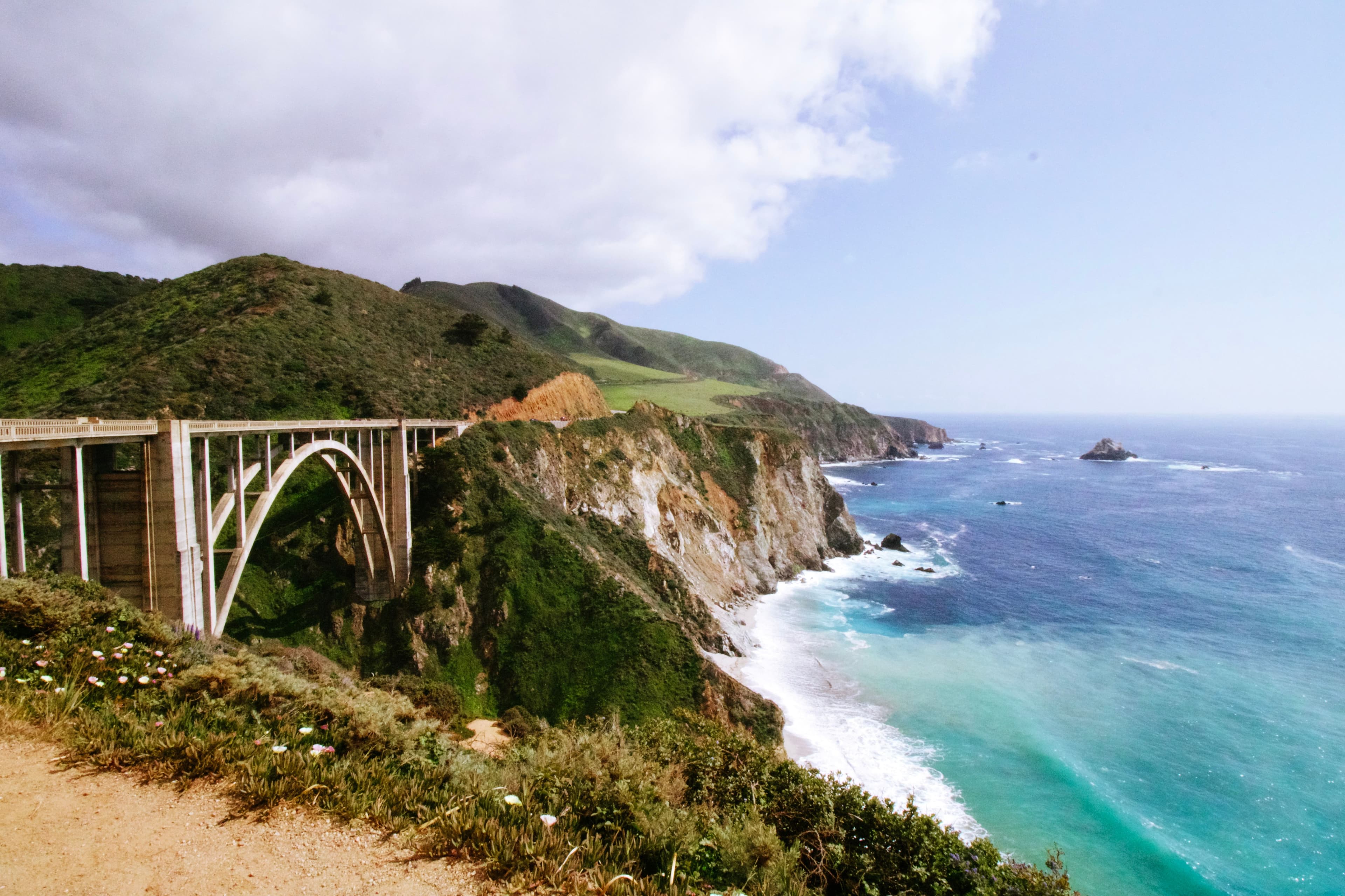
Roughly halfway through the race, at Bixby Bridge, the organiser stages a piano performance on the course, timed to the descent off Hurricane Point. It is one of the details returning runners mention most often, and it sits at a point in the race where the climb has just been dealt with and the rolling, wind-exposed second half is about to begin. Runners planning their effort around Hurricane Point should expect this moment shortly afterwards rather than treating the bridge as just another mile marker.
History
Bill Burleigh founded the Big Sur International Marathon in 1986, having pursued the idea of closing a stretch of Highway 1 for a spring marathon between Big Sur and Carmel. The obstacle was never demand. It was permission: Highway 1 is a working coastal route, and staging a marathon on it meant securing a temporary closure and finding a date that avoided both the summer tourist crush and the autumn sports calendar. The first edition ran on the last Sunday of April 1986, with 1,800 runners.
From the outset the race was built around its course rather than a city centre. The proposition was a full marathon on the Pacific coast, starting among redwoods and finishing near Carmel. Shorter events followed: an 11-miler, a 21-miler, a relay and a 5K, but the full marathon kept the identity of the original point-to-point Highway 1 route. Weather and geology have shaped the event more than once. Flooding destroyed the Carmel River Bridge in 1995. Highway 1 collapses and landslides forced course changes in 1998, 2011 and 2024, and the 2025 race returned to the traditional point-to-point route after the previous year’s slip-out reroute.
Brad Hawthorne set the men’s course record of 2:16:39 in 1987; it still stands. Svetlana Vasilyeva ran the women’s record, 2:41:34, in 1996. Both times are notable given a course with sustained climbing and exposed coastal wind: this is not a race built for personal bests. Big Sur pays no prize money, appearance money, hotel or travel assistance, though a small quota of complimentary elite entries goes to athletes who meet published time standards.
The race today is a capped, lottery-entry destination marathon with an international following, closer in spirit to a scenic pilgrimage than a mass-participation Major. It occupies the late-April scenic slot in the calendar: a draw for experienced runners, for Boston finishers attempting the Boston 2 Big Sur challenge, and for travelling runners who rate course character above finishing time.
The course
The course runs point-to-point on closed Highway 1 from the Pfeiffer Multi-Use Big Sur Station to Carmel, on the last Sunday of April. The first mile is a fast downhill through redwood forest, using both lanes of the highway. Runners leave redwood shade by around mile 4 and move onto increasingly open, pastoral coastal road, with the Pacific visible to the right and coastal hills to the left. The defining physical feature is the climb to Hurricane Point, a 2.15-mile ascent beginning at mile 9.85 with an average grade of 4.52%, followed by the descent to Bixby Bridge at the 13.1-mile halfway mark, where the organiser stages a piano performance. The final 10K runs through the Carmel Highlands, a series of short, sharply cambered rollers, before a last climb at mile 26 (“D-Minor Hill,” roughly a quarter-mile long, rising about 90 feet) and a gentle descent across the Carmel River Bridge to the finish near Rio Road and Crossroads Carmel.
Official course elevation data gives a start elevation of 356 ft (109 m), a finish elevation of 10 ft (3 m), and total elevation gain of 2,182 ft (665 m) against 2,528 ft (771 m) of loss. An independent GPX-based analysis gives a different, lower figure for total ascent and descent (1,722 ft / 1,990 ft); the two do not reconcile, likely reflecting different measurement methods (an official course-profile survey versus GPX-track elevation smoothing), and this page uses the official figure as primary. A course-certified GPX file also measures the routed distance at 42.27 km (26.27 miles), slightly over the certified 42.195 km, which is normal for a GPX track and not itself a course-length error. The surface is paved highway throughout, without the switchback turns of an urban course, but with long exposed sections, coastal camber (especially through the Carmel Highlands) and wind exposure.
Km 0-6.4 (Mile 0-4): The redwoods and the early descent.The race starts at 6:45am at the Pfeiffer Multi-Use Big Sur Station. The first mile is a fast, sweeping downhill through giant redwoods, using both lanes of Highway 1, and it is easy to go out too fast here: the course’s own briefing material warns runners to conserve their quads for the climbs to come. Runners pass Big Sur Village (aid station, km 4.0 / mile 2.5) and the River Inn (km 4.8 / mile 3) before the downhill runs out around km 6.4 (mile 4), where oak and pine begin to replace redwood.
Km 6.4-12.9 (Mile 4-8): Pastoral coast and the first climb.The scenery opens into pastoral meadows, with the Pacific visible to the right and coastal hills to the left; horses and cattle are a regular sight in the fields. This exposed stretch brings the first real test of coastal wind. Runners pass Andrew Molera State Park (aid station, km 7.7 / mile 4.8) before a long gradual rise begins around km 11.3 (mile 7), turning into the course’s first genuinely steep climb just past km 12.9 (mile 8), where a clear day gives a view of the historic Point Sur Lighthouse (built 1889) on its volcanic outcrop.
Km 12.9-19.3 (Mile 8-12): Hurricane Point.A sweeping, nearly mile-long descent to the Little Sur River Bridge (around km 14.5 / mile 9) offers recovery before the course’s defining feature: a 2.15-mile climb beginning at mile 9.85 (km 15.9), averaging a 4.52% grade and gaining roughly 513 ft. Taiko drummers are stationed around the halfway point of the climb (near mile 11 / km 17.7). The climb is steady rather than technical, but sustained; official guidance is to hold a consistent, sustainable effort rather than attack it.
Km 19.3-21.1 (Mile 12-13.1): The descent to Bixby Bridge.Cresting Hurricane Point brings both relief and one of the race’s signature moments: the sound of a grand piano, played live near the halfway point below. A long, winding descent (1.03 miles, averaging a -5.5% grade) leads to Bixby Bridge, crossed at the 13.1-mile halfway mark. This is the course’s most-photographed moment and, on tired legs, the point where the physical difficulty of the second half starts to register.
Km 21.1-32.2 (Mile 13.1-20): The rolling middle section.The second half is defined by continuous rolling terrain rather than one further big climb: 19 separate significant climbs and 19 significant descents are recorded across the full course by GPX analysis, and most of the remaining ones fall in this stretch. Runners cross Rocky Creek Bridge (km 22.5 / mile 14) and pass the Grimes Ranch 11-Miler start and Palo Colorado Canyon aid station (km 24.1-25.7 / mile 15-16), then Garrapata Bridge (km 27.4 / mile 17) and Granite Canyon Bridge (km 29.0 / mile 18). At km 32.2 (mile 20), runners reach “The Wall,” a towering dirt cliff at the traditional marathon breaking point; it is a psychological landmark rather than a further climb, and marks the start of the approach to the final 10K.
Km 32.2-34.1 (Mile 20-21.2): The timing gate. Civilisation reappears gradually from mile 21 (km 33.8): houses, then people, then sporadic unofficial local aid. The official mile 21.2 (km 34.1) timing gate falls in this stretch, requiring an 11:50am pace for runners working to the six-hour cutoff; the earlier mile 15.2 (km 24.5) gate, passed during the previous section, required a 10:30am pace. Missing either gate ends the race as a supported event.
Km 34.1-38.6 (Mile 21.2-24): The Carmel Highlands. Crossing Malpaso Bridge at km 35.4 (mile 22) marks the formal entry into the Carmel Highlands, a series of short, steep rollers made harder by a sharply cambered road surface that strains ankles and IT bands after 34 km of running. Crowd support strengthens noticeably here, including a well-known unofficial party stop at the Highlands Chevron station (km 38.6 / mile 24), with live music and strawberries handed out by local children. The road flattens and the wind typically drops through this stretch.
Km 38.6-42.2 (Mile 24-26.2): Point Lobos to the finish.Runners pass the entrance to Point Lobos State Natural Reserve around km 40.2 (mile 25), with glimpses of the Carmelite Monastery inland. The final test is “D-Minor Hill” at mile 26 (km 41.8): a short, steep climb of roughly 90 ft over about a quarter mile, positioned deliberately close to the finish to test whatever is left in the legs. Cresting it reveals the finish banner in the distance. The mile 26 marker sits at the far end of the Carmel River Bridge, and the remainder of the course is a gentle, celebratory downhill to the finish near Rio Road and Crossroads Carmel.
The blue tangent line should be followed throughout. On a point-to-point coastal road with sweeping curves rather than tight corners, holding the tangent still makes a measurable difference over 42.195 km.
A fast downhill start through redwood forest gives way to open, pastoral coastline, with the course’s first real climb arriving around km 12.9 (mile 8) beneath the Point Sur Lighthouse.
The course’s defining climb, a sustained 2.15-mile ascent at an average 4.52% grade, followed by a long descent to the halfway-point piano performance at Bixby Bridge.
Continuous rolling terrain rather than one further big hill, punctuated by "The Wall" at km 32.2 (mile 20) and the mile 21.2 (km 34.1) cutoff gate that requires an 11:50am pace.
Short, sharply cambered rollers through the Highlands, a final climb at "D-Minor Hill" (mile 26), and a gentle descent across the Carmel River Bridge to the finish.
Pacers
Official pace teams run for 18 goal times: 3:00, 3:10, 3:20, 3:30, 3:40, 3:50, 4:00, 4:10, 4:15, 4:20, 4:30, 4:40, 4:45, 4:50, 5:00, 5:15, 5:30 and 5:50. Wave and corral assignment by pace group has not been published; check the current-year Pace Teams page or participant guide closer to race day. Unofficial pacers, meaning anyone outside the official programme pacing informally, are explicitly prohibited on course under official race rules. The six-hour cutoff, with intermediate gates at mile 15.2 (10:30am) and mile 21.2 (11:50am), remains the benchmark for runners targeting a time outside the official pace list.
What to wear
Race morning starts cold: temperatures typically sit in the low-to-mid 40s°F (roughly 6-9°C) at the 6:45am start, under cloud cover or coastal fog, at the remote Pfeiffer Big Sur Station. A throwaway layer is close to essential given the early buses and the wait before the gun. Conditions shift through the morning rather than staying fixed. By mid-morning, as the fog typically burns off, temperatures rise into the mid-50s°F (roughly 12-13°C), and runners finishing later in the field should expect stronger direct sun than those who start in fog. Official course material specifically warns of headwinds along the exposed coastal sections of Highway 1; a tailwind occurs in some years but is the less common outcome. Layer for a cold, damp, windy start that can be shed, rather than for the temperature expected at the finish, and carry sun protection even if the morning looks overcast.
Entry
Entry to the 2027 Big Sur International Marathon is by random drawing. The lottery opens 19 August 2026 at 8am PT, stays open for two weeks until 2 September 2026, and results are announced 8 September 2026. A guaranteed-entry path opens the same day as the lottery, on a first-come basis, for runners who would rather not gamble on the draw. Non-marathon distances (21-Miler, 11-Miler, 12K, 5K, relay) open separately on 10 September 2026. The Boston 2 Big Sur Challenge, which pairs this race with the Boston Marathon two weeks earlier, opens 14 October 2026 and requires the entrant to hold a confirmed Boston Marathon entry.
The 2026 marathon entry fee for the random drawing was $295; treat this as indicative only pending the 2027 registration page. There is no confirmed guaranteed-entry route for ordinary fast runners based on age-graded time standards. This is not a Boston-style GFA system. A small quota of complimentary elite entries exists instead, for athletes meeting fixed time standards regardless of age category, and the race pays no prize money, appearance fees, or travel and hotel assistance even to elite entrants.
Elite Quota Standards
Big Sur does not operate an age-graded GFA table. The relevant standard is a single elite-quota threshold (any age, within the previous 24 months), shown below in place of the standard age-banded table.
| Elite quota: Men | 2:27:00 |
|---|---|
| Elite quota: Women | 2:59:00 |
| Elite quota: Non-Binary | 2:59:00 |
| Ordinary guaranteed-entry route by time standard | Not applicable, no such route exists for this race |
Race Weekend
Expo
The Health & Fitness Expo is held at the Monterey Conference Center, 1 Portola Plaza, Monterey. For the 2026 edition it ran Friday 12-6pm and Saturday 9:30am-6pm, the two days before the Sunday race; exact 2027 dates and hours follow the same Friday/Saturday pattern but should be checked against the current-year event page before travelling.
Bibs and shirts must be collected in person: each runner collects their own, and friends or family are explicitly not permitted to collect on another participant’s behalf, with no exceptions stated on the official page. Collection requires photo ID and a check-in pass (a QR code plus bib number, emailed to registered runners ahead of the event). Because the start is a remote coastal location with no infrastructure for bib pickup, this in-person Expo collection is the only route to a bib; there is no start-line pickup option. Official merchandise is sold at the Expo and separately at Marathon Village on race day; items ordered online before the Thursday before race day can also be collected at the Expo.
Race Morning
Race morning is transport-led rather than walk-to-the-start, and that shapes almost every other decision. Because Highway 1 is closed to private vehicles on race morning and there is no start-area parking or drop-off, official bus transport to the remote start is mandatory for every marathon entrant who is not staying overnight in Big Sur itself. The race begins at 6:45am.
Runners select a preferred pickup location in advance through their “haku” participant account, with selection opening in March of race year. Those who pre-select a pickup point collect their bus ticket together with their bib at the Expo. Runners who don’t pre-select are directed to the Transportation Desk at the Expo to be assigned a ticket from whatever pickup options remain. Runners staying overnight in Big Sur itself use a different, local system: two continuous shuttle loops running on Highway 1 from 4:45am to 5:45am, one covering roughly two miles north of the start toward the River Inn, the other roughly two miles south toward Deetjen’s; these runners wait roadside on Highway 1 for a shuttle rather than travelling to a fixed pickup point.
Two intermediate cutoffs govern the race once it starts: mile 15.2 (km 24.5) by 10:30am, and mile 21.2 (km 34.1) by 11:50am, with an overall six-hour limit from the 6:45am start.
After finishing, runners exit through the Carmel finish festival at Marathon Village. Return shuttles run from the finish village back to each runner’s original morning departure point between 9:30am and 2pm; runners who started from Big Sur return via the same local shuttle loops used that morning. Carry nutrition you already know you tolerate rather than relying solely on the aid stations, and expect a bring-your-own-layer approach given the remote, bussed start.
Logistics Map
The map below shows the point-to-point route on closed Highway 1 from Big Sur Station to Carmel, with the course’s named landmarks and the Monterey Conference Center expo venue. Tap any marker for details.
Nutrition on Course
Precision Fuel & Hydration is the official nutrition partner, and the course carries 11 aid stations at roughly every 2 to 3 miles, plus one strawberry-only station. Water and Precision Hydration PH 1000 sports drink are available at every regular station. Precision Fuel PF 30 gel is provided at two specific points: mile 12.2 (km 19.6, at the Hurricane Point summit aid station) and mile 19.0 (km 30.6). Fruit appears at later stations, with a dedicated strawberry station at mile 23.2 (km 37.3), near the Highlands Inn. Portable restrooms, first aid and water-bottle refill points are available at aid stations along the route.
Given the confirmed wind exposure and the point-to-point layout, runners who rely on a specific gel or drink brand should carry their own rather than assume timing will line up with the two confirmed gel stations at mile 12.2 and mile 19.0.
Spectating
Spectating Big Sur is harder than a typical city marathon: Highway 1 access is restricted during the race, the course is point-to-point rather than a loop, and there is no metro or rail system to move spectators along the route. The most reliable plan is to pick a finish-area base in Carmel or Monterey rather than attempt to follow the runner along the course, and to see them once, at the finish festival at Marathon Village near Rio Road and Crossroads Carmel. A fixed viewing point in the Carmel Highlands is usable only if official road-closure guidance permits access on the day. Following the runner along the closed highway itself is not realistic for most spectators without official race-permitted transport.
Post-Race Food
Plan post-race food around Carmel or Monterey rather than the remote start, since there is nothing at Big Sur Station itself. Peter B’s Brewpub, at the Portola Hotel in Monterey and an official race partner, works well for groups wanting simple carbohydrate- and protein-heavy food after finishing. Alvarado Street Brewery in Monterey is a good casual option if transport back into Monterey is straightforward. Flaherty’s Seafood Grill & Oyster Bar in Carmel suits runners staying on the Carmel side who want a sit-down meal, though booking ahead is sensible on race weekend given the number of runners and supporters in town at once.
Where to Stay
The finish is in Carmel, but where to stay depends more on logistics than on finish proximity, because the start is remote and bus-dependent regardless of hotel location.
Carmel-by-the-Sea
The most finish-convenient base and the most expensive. It sits closest to the finish festival, with a short taxi, shuttle or walk depending on the specific hotel. The town is quiet, at a high price point. Choose Carmel if recovery and finish access matter more than budget; avoid it if you need lower-cost lodging or an evening out beyond the town’s understated pace.
Monterey downtown
Around the Portola area, Monterey offers the most practical balance for expo access, shuttle logistics and post-race restaurants, and is likely one of the more useful bus bases for race morning. It is not walkable to the finish, so transport is required either way. Prices run moderate to expensive on race weekend. Choose Monterey if easiest overall logistics matter more than a slower village pace.
Pacific Grove
A quieter coastal base with good recovery walks, at often slightly better value than Monterey or Carmel. Choose it for calm surroundings and ocean walks; avoid it if late-night food options matter.
Carmel Valley
A resort-style recovery base, more expensive and more spread out than the coastal towns, and effectively requires a car or taxi to reach the finish. Choose it for a longer stay built around recovery rather than race-day convenience; avoid it without a car.
Big Sur lodges
Close to the start and far from the finish: romantic, expensive, limited in supply, and logistically the riskiest option for anyone but the runner using the local Big Sur shuttle loop system on race morning (see Race Morning above). Choose this option only if the landscape is the priority and the local shuttle system works for the stay; avoid it if simple, predictable race-day movement matters more.
Recommended hotels
A large, event-friendly hotel and an official race partner (home to Peter B’s Brewpub), useful as a base for expo and shuttle logistics, though it is not finish-adjacent and requires transport on race morning and after finishing.
A reasonable compromise on the finish side of town, closer to the festival than most Monterey options, though prices can spike sharply around race weekend.
A large, full-service property that suits groups, but less walkable to Monterey’s evening food options than a downtown base.
Sits in Carmel’s village character, with recovery-friendly walking distance around town, though room count is limited, so it books out early.
Useful if pairing the race with a visit to the Monterey Bay Aquarium (also an official race partner), given the Cannery Row location, though the tourist area is busy year-round and especially on race weekend.
Booking timeline
Enter the 2027 drawing first, since results are due 8 September 2026, but book refundable accommodation as soon as the race becomes a serious goal rather than waiting for lottery confirmation. The marathon’s small entrant cap sits against a limited hotel supply across Carmel and Monterey, so rooms in the most finish-convenient parts of Carmel are likely to become expensive first. Monterey has a larger hotel stock and generally more practical race-morning logistics, a reasonable fallback if Carmel books out or its prices climb too far. International travellers should look at San Francisco, San Jose and Monterey Regional airports; road travel time across the Monterey Peninsula makes flight arrival timing worth planning around.
See & Do
The finish sits in Carmel-by-the-Sea, with Monterey and the wider Peninsula within easy reach by car or short taxi.
Monterey Bay Aquarium
A largely indoor anchor for the day before or after the race, useful given April sits outside peak summer crowds, and an official race partner. Timed tickets should be booked ahead. Manageable on tired legs if the standing time is paced.
Point Lobos State Natural Reserve
A striking stretch of protected coastline just south of Carmel, passed directly by the marathon course around mile 25 (km 40.2). Best visited a day or two after the race rather than immediately post-marathon given the walking and parking involved. April can bring wildflowers, though weather and parking availability vary.
17-Mile Drive
Best experienced by car, which makes it a good option for tired legs the day after finishing. There is an entry fee and road conditions should be checked seasonally.
Carmel Beach
A low-effort recovery walk with a strong sunset option, right in Carmel. April wind can make it chillier than expected, so bring a layer even on a short walk.
Read Before you Run
Cannery Row
John Steinbeck
Set in the Monterey waterfront district that gives the book its name, this is the strongest pre-race read for runners basing themselves in or near Cannery Row, and it sharpens the sense of place before race weekend.
The Grapes of Wrath
John Steinbeck
A wider read on the California landscape and the Salinas region inland from the race route, useful for runners extending their trip beyond the coast rather than a Monterey-specific companion piece.
After the Race
The Big Sur International Marathon runs in late April. These itineraries range from a same-day trip to Monterey to a four-night extension inland to Yosemite.
A low-effort day built around the Monterey Bay Aquarium and the flat coastal trail along Cannery Row, easy to manage on tired legs. Mostly indoors, so April’s changeable fog and sun matter less here than anywhere else on this list.
The simplest extension: stay where the race finished, and use the extra day for Point Lobos, the stretch of protected coastline just south of Carmel that previews the Big Sur scenery the marathon itself runs past.
A beach-town extension around the bay, built around the flat coastal path on West Cliff Drive rather than the cold-water beaches themselves. April is shoulder season here, so this is a sightseeing trip, not a sunbathing one.
A classic city extension before flying home, anchored on the flat Embarcadero waterfront rather than the city’s hills, which are hard going on legs still recovering from the marathon.
A bigger nature extension inland, valley-floor-focused rather than high-country, since Tioga Pass and Glacier Point Road are typically still snow-closed in April. Spring snowmelt means the waterfalls are close to their best.
Frequently asked questions
Should I stay near the start or the finish?
Stay near the finish, in Carmel or Monterey, or near your selected official bus pickup point. The start at Big Sur Station is remote, so staying near it only works if you’re using the local Big Sur shuttle loop rather than the main bus system.
How far in advance should I book a hotel?
Book a refundable room as soon as the race becomes a serious goal, well before the lottery result. Confirm or adjust the booking once 2027 results are announced on 8 September 2026, since hotel supply across Carmel and Monterey is limited relative to demand on race weekend.
Is there free transport to the start?
Yes. Official bus transport is mandatory for every marathon entrant not staying overnight in Big Sur, since Highway 1 is closed to private vehicles on race morning. Pickup location is selected in advance through the runner’s participant account.
What is the best area to stay?
Carmel is best for finish convenience and recovery, at a higher price. Monterey offers more hotel supply and is likely one of the more practical bus bases for race morning. Pacific Grove is a quieter, sometimes better-value alternative to both.
When does the expo open?
The Health & Fitness Expo runs at the Monterey Conference Center on the Friday and Saturday before race day (Friday midday-6pm, Saturday 9:30am-6pm in 2026). Bibs must be collected in person with photo ID; no proxy pickup is permitted.
What is the weather typically like?
Expect a cold start in the low-to-mid 40s°F (roughly 6-9°C), often under coastal fog, warming into the mid-50s°F (roughly 12-13°C) by mid-morning as the fog clears. Headwinds along the coast are common. Dress for a cold, exposed coastal morning rather than a flat city marathon.
How do I get from the airport?
Most travellers arrive via Monterey Regional, San Jose or San Francisco airports and then drive or take a shuttle to Monterey or Carmel. Road travel time across the Monterey Peninsula is worth building into flight planning.
Is there a bag drop?
Bag-drop procedure should be checked against the current year’s official participant guide before assuming it is available.
Should I bring a throwaway layer?
Yes. The remote start, early bus transfers and cold, often foggy conditions before the 6:45am gun make a disposable warm layer close to essential in most years.
How do I get back to my hotel after finishing?
Official return shuttles run from the finish village back to each runner’s morning departure point between 9:30am and 2pm. Runners who started from Big Sur return via the same local shuttle loop used that morning.