The Race
The organiser calls this an urban adventure marathon. The roads are not closed, marshals are few, surfaces change and the distance is the organiser's figure with no certificate. Carry the route on your watch and walk the first 5 km beforehand.
| Next Race Date | Sunday 14 March 2027, start 07:00 |
|---|---|
| Course type | Point-to-point, Avenida Abdón Saavedra to Parque Bartolina Sisa, Aranjuez |
| Registration | Open online entry through Webscorer; no cap; medical certificate required |
| Ballot opens | No ballot |
| Total finishers | Not published |
| Average race day temperature | March mean 8.8°C at the El Alto weather station, which sits above the city |
| Cutoff time | Not published |
| Free race-day transport | None found |
| Course certification | None found; the 42.2 km is the organiser's figure |
History
The first race was run on 10 March 2013 as the Maratón por la Paz. It had no half marathon and no shorter races, only the full distance, and complete results were published by SOBOCE. The race is organised by Cristian Conitzer with his family and collaborators, under the name Conitzer Running.
The 2027 race is the 15th edition, and the archive carries a tenth edition on 13 March 2022. The event now adds a half marathon, a 10 km and a 5 km, and the registration form also sells remote participation. Those who complete the virtual option have not run the La Paz course and should not be counted as finishers.
The course keeps changing. The 2025 street instructions put the start near a university and the finish at Cancha Los Rosales. The 2026 timing sheet used a different early route and ended at the entrance to Parque Bartolina Sisa. The 2027 route starts at a bakery on Avenida Abdón Saavedra and uses a different half-marathon start on the Periférica. That affects hotel choice, spectator plans and any comparison between years.
The organiser describes the event as an urban adventure and not a large closed-road race. Surface instructions in earlier years mentioned cobbles, stone paving and dirt along with asphalt, and a participant who ran the 2022 half marathon wrote that the route was not cordoned off and that following it needed a watch map. Treat it as a navigation exercise as well as a long run.
No record progression or recent results are published. The 2026 edition closed with 360 participants.
The course
The marathon starts at Panadería Leo Nothmann, Avenida Landaeta 514 at Avenida Abdón Saavedra, at about 3,630 m above sea level, and finishes at Parque Bartolina Sisa in Aranjuez, 6.9 km away in a straight line and 408 m lower. The route does not cross itself and is not closed to traffic.
The course drops 141 m in the first 4 km through a loop of turns and a U-turn on Avenida Francisco Bedregal, to 3,503 m on Avenida Libertad. It then climbs 444 m over 9.2 km (4.8%) north-west along Avenida Aniceto Arce, Avenida América and Calle Coro Coro, to about 3,930 m on Avenida Prolongación at km 13.5. A 185 m drop to 3,754 m at Avenida Chacaltaya at km 18 is followed by a second climb of 207 m (2.7%) along the Periférica on Avenida General Juan José Torres González, to the course's highest ground at 3,960 m near km 26.
From there the course turns south-east for a descent of 732 m over 16 km (4.5%). It passes Avenida Bicentenario de la Revolución de 1809, Avenida Circunvalación, San Antonio and Avenida René Zavaleta Mercado, and follows Avenida Los Leones, Avenida 14 de Septiembre and Avenida Mecapaca to a roundabout at the Club de Tenis, then the Mallasa cycle path into the park, at 3,225 m. The organiser's summary also names Pura Pura, Achachicala, Villa El Carmen, Chuquiaguillo, Villa Copacabana, Bajo San Antonio, Zabaleta and Mecapaca along the way.
Kilometre by kilometre
Km 0 to 5: the warm-up loop. The start is a sharp right onto Calle Abdón Saavedra, followed by a gentle left, then a left onto Avenida Víctor Agustín Ugarte at about km 1.7. The route drops to Avenida Francisco Bedregal and then twists through a series of turns and a U-turn at around km 2.9, so you will see runners coming back towards you. This is the easiest place to take a wrong turn on the course. The line then rejoins Avenida Aniceto Arce at about km 4.4, the lowest point of the first half.
Km 5 to 13: the climb. From km 5 the course goes up and does not stop for about eight kilometres, 444 m at an average 4.8%. It turns left onto Calle Serrano near km 7.7, takes the first exit at the roundabout onto Avenida Manco Kapac at km 8.4, turns left onto Calle Coro Coro near km 11 and works through Calle 3 and Calle 4 between km 12.5 and 13.3 before the roundabout onto Avenida Prolongación. This is where most runners at this altitude pay for a fast start.
Km 13 to 27: up on the Periférica. The course drops 185 m to Avenida Chacaltaya at km 17.7, climbs again along Avenida General Juan José Torres González, and reaches its highest ground at 3,960 m near km 26. A left onto Avenida Bicentenario de la Revolución de 1809 follows at km 27.1. The air is thinnest here.
Km 27 to 36: down through the suburbs. The descent starts with Kantuta at km 29.6 and a turn onto a road marked SN20, then a quick run of turns around Avenida Vicente Burgaleta between km 31.7 and 32.4. The route then follows Avenida Regimiento Castrillo, takes the third exit at the roundabout onto Avenida René Zavaleta Mercado near km 34.2 and the second exit onto Avenida Los Leones at km 35.8. Gradients of 5 to 7% run through here. Earlier editions mentioned cobbles in this part of the city, so expect surfaces to change.
Km 36 to 42.2: the long drop to Aranjuez. Avenida 14 de Septiembre starts at km 36.3 and Avenida Mecapaca takes over at about km 38.7. The last 6 km lose 140 m, and the quads feel it. Turn right onto Calle Benito Juárez at km 41.0, take the second exit at the roundabout at the Club de Tenis, then turn left onto the Mallasa cycle path for the final stretch into Parque Bartolina Sisa.
Navigation. Load the route onto a watch with turn alerts and walk or drive the first 5 km beforehand. The organiser encourages route reconnaissance. Pace by effort and not by sea-level targets, and plan your arrival in La Paz before you plan your race.
Turns come thick and fast on Abdón Saavedra and Francisco Bedregal, with a U-turn at km 2.9. Know them before race morning.
The climb begins at km 5 and gains 444 m to Calle Coro Coro and Avenida Prolongación. Hold back.
A 185 m drop, then 207 m up on wide roads to the highest ground of 3,960 m near km 26. Effort over pace.
Down 732 m through Kantuta, Los Leones and Mecapaca to the cycle path. Your quads will notice.
Course Map
The 2027 course from Avenida Abdón Saavedra north-west up to the Periférica and then south-east down to Aranjuez, where it finishes in Parque Bartolina Sisa. Tap a marker for details, and scrub the slider or press play to move the orange marker along the course with the elevation profile beneath it.
Pacers
No official pace teams had been announced when this page was written. Check the organiser's channels nearer the race.
La Paz sits at about 3,630 m and the course runs between roughly 3,200 and 3,960 m. Being fit does not protect you from altitude illness. Plan your arrival as carefully as your pacing, and speak to a travel-health adviser before you fly.
The start, finish and half-marathon start have moved between editions. Older blogs and spreadsheets describe other routes. Use the address and map for the current edition.
The registration form also sells a remote option. Only runners on the La Paz course are finishers of the race.
March is the wet season. The Japan Meteorological Agency's long-term figures for the El Alto station, which sits above the city at 4,058 m, give a March mean of 8.8°C and 82 mm of rain. The route runs between roughly 3,200 and 3,960 m, so the start at 07:00 and the high section can feel cold and the lower finish milder. Those are monthly means for a different station, not a forecast for race morning.
The municipal tourism office recommends April to October as the drier months, so a March race can bring rain and wet ground. Carry a light shell that fits in a belt. Sunscreen and sunglasses matter at altitude, where the sun is strong even on cool days.
Choose layers you can remove, because the course falls about 400 m from start to finish. Shoes with grip help on cobbles, dirt and wet paving. Bring a charged watch with the route loaded, since the course is not closed and has few marshals to point the way.
Entry
Entry is online through Webscorer, open since 14 June 2026, with no cap. Online registration closes on Monday 8 March 2027 at 20:00 (UTC-4), and the organiser disables in-person sign-up at the last minute because of the chips, insurance and medals. There is one price, 170 bolivianos, and it includes insurance, a bib, shirt, chip, food and water on the course, a finisher medal and a meal at the finish. There is no ballot, no qualifying time and no charity or tour-operator allocation. The age categories for the marathon are 18 to 34, 35 to 49 and 50+, and they decide awards, not entry.
You need a medical certificate and, per the homepage, a birth year of 2009 or earlier. Work out how that applies if you turn 18 later in the year. The form asks for your contact and emergency-contact details, and a passport or identity-document number.
For overseas entrants, the organiser lists three payment routes: a euro bank transfer, PayPal, and a card route through World's Marathons. Its English notes quote EUR 22 or USD 22. Complete the Webscorer registration with your transaction reference whichever route you use, and check the amount shown at the time of payment.
The 2027 rules document returned an error when this page was written, so refunds, deferrals, transfers and the cutoff are unknown. The included insurance is not a travel-insurance policy. Take out your own cover, and check that it covers a race at altitude.
British citizens can visit Bolivia visa-free for up to 90 days in a year, with a passport valid for at least six months on arrival and two blank pages, and officials may ask for proof of your first accommodation. Yellow-fever rules depend on where you travel from. UK government advice also reports a State of Emergency and disruption from protests and roadblocks, and advises against all but essential travel to Chapare. That does not close La Paz, but keep onward transport flexible and read the current advice before booking.
See the organiser's site →Race Weekend
Bib collection
Collection is at Panadería Leo Nothmann, Avenida Landaeta 514, opposite Avenida Abdón Saavedra, on Friday 12 and Saturday 13 March 2027, between 10:00 and 18:00. It is the same bakery as the marathon start. This is a collection desk and not an expo.
The registration form asks for a transaction reference and an identity or passport number. The homepage also requires a medical certificate for the marathon. The detailed rules, which would say what you must show and whether someone else can collect for you, could not be read. Bring your payment confirmation, your passport and your medical certificate.
Do not use older route instructions to plan your arrival. The 2025 transport sheet pointed marathon runners to a different plaza and university area. Use the address above, and check the walk from your hotel, since hills and steps are everywhere in La Paz.
Getting to the start
The marathon starts at 07:00 at Panadería Leo Nothmann on Avenida Landaeta, at Avenida Abdón Saavedra. The half marathon starts at 09:00 on the Periférica, near the Unidad Educativa Costa du Rels, the 10 km at 10:10 on the Villa Copacabana side of Puente Unión del Bicentenario, and the 5 km at 10:10 in Obrajes on Avenida 14 de Septiembre. Every distance finishes at Parque Bartolina Sisa in Aranjuez.
This is a point-to-point race. A hotel near the start is easy at dawn and leaves a long trip back after the finish, while a hotel in the south is the reverse. No race shuttle has been announced. Public transport is mentioned in general terms, and the cable-car network is a verified attraction, but no Sunday timetable is published that would put you at the start before 07:00. Arrange a prebooked hotel car or a walk you have tried.
Plan your own navigation. The course is not closed, and the organiser calls it an adventure marathon. Have the route on a watch, know where you will withdraw, and keep a phone with a local number or roaming switched on.
Do not arrive in La Paz and run a few days later. Travel-health advice is that gradual ascent and rest on arrival are wise, and that being fit does not protect you from altitude illness. Confusion, poor coordination or breathlessness at rest need urgent medical help. Speak to a travel-health adviser before you fly.
After the race, decide where your dry clothes, bag and ride are. No bag transfer from the start to the finish was found. Do not assume you can drive to the park exit.
Nutrition on course
The entry fee includes food and water on the course, and the homepage mentions hydration points and volunteers at key points. It does not say where, how often or what is served.
An earlier timing sheet listed supply points at the start, km 13, km 17.9 and km 36.8 and the finish, with coffee and biscuits at the old start. Those positions belong to a different route and are not a plan for this one.
Carry your own fuel and a bottle, and expect to run longer between water stops than you would in a city road race. Check the organiser's current aid list before you decide how much to carry. Altitude also makes dehydration easy to miss, so drink to a schedule.
Spectating
Plan one sighting at the finish and, if you have a car and a driver, one in the last 3 km. The old kilometre sheets belong to earlier routes, so ignore any list of spectator points you find online. No spectator ticket rule, live tracking or crowd map was found.
Watching the 07:00 start at the bakery on Avenida Landaeta and then travelling south needs a driver and a road you have checked, because no reliable Sunday timetable or walking route between the two was found. Allow for the runner's time, which at this altitude and on this profile could be well beyond the sea-level equivalent.
Avenida Mecapaca near the finish carries the route from about km 38.7 to km 41. A driver can drop you there, then take you to the park. Check that the road is open to cars and where you can stand. Do not plan a mid-race stop on the Periférica or Avenida Prolongación, which have no verified spectator access.
- Meet in Parque Bartolina Sisa in Aranjuez.
- Confirm that the park is open to the public and agree a meeting point outside the runner exit.
- No shade, seating or pickup arrangements were found.
Post-race food
The entry fee includes a meal at the finish. Nothing else about it was published, so eat what is given, then go on to a proper lunch if you want one.
Terra Restaurant, at the Stannum hotel on Avenida Arce in San Jorge, serves à-la-carte bistro dishes and seasonal products. Its website does not give race-Sunday kitchen hours, so ring first. Proyecto Nativa, at the Atix hotel on Calle 16 8052 in Calacoto, appears on the hotel's homepage, but its own page returned an error. Confirm Sunday service and the address before you book.
Atix is about 2.2 km from the finish in a straight line and Stannum about 6 km, so neither is within walking distance. Book a window and not a fixed time, since altitude can slow a finish more than you expect.
Where to Stay
The finish is in Aranjuez, in the south of the city, and the start is on Avenida Abdón Saavedra, in the centre-south. For a point-to-point race the principle is to stay near the finish, because you will be tired and your bag may not travel with you. A base in the southern zone puts you closer to Parque Bartolina Sisa and means a pre-booked drive to the start before 07:00. A central base reverses that.
Calacoto and the Zona Sur
Atix (Calle 16 8052), Casa Grande Hotel (Calle 16 8009) and Rosario La Paz Sur are all here, about 2 km from the finish in a straight line and 6.5 km from the start. It suits runners who want to finish near their room and are happy to arrange an early car. The hotel group says the Rosario property is at about 3,300 m, which is a location fact and not medical reassurance.
Sopocachi and San Jorge
Stannum Boutique stands on Avenida Arce, about 1.2 km from the start and 6 km from the finish, and has Terra Restaurant on site. It lists early and late departure on direct bookings, subject to availability, and a transfer offer for a three-night booking. That transfer is not a marathon shuttle.
The historic centre
La Casona Boutique and Rosario's central property suit visitors who want the old city, about 1.2 km from the start. Ask about steps, lifts, vehicle access and luggage storage, because a hotel on a hill is a hard way to end a marathon.
No price comparison, noise pattern or race-weekend rate could be established, and no area is recommended above another on cost. Whatever you choose, arrive well before the race, ask about a very early breakfast, and keep your room until you have the bag, a shower and a ride.
Recommended hotels
Calle 16 8052. A southern base with its own restaurant, Proyecto Nativa, which has no confirmed Sunday service. Arrange an early car to the start. No race shuttle was found.
Calle 16 8009. A full-service hotel in the south, and further from the start than the central options. Arrange an early transfer.
Avenida Arce. Has Terra Restaurant on site and lists early and late departure on direct bookings, subject to availability. Its transfer offer for a three-night booking is not a marathon shuttle.
A historic-centre base for visitors who want the old city. Ask about steps, vehicle access and a very early breakfast before you book.
The group's southern property, described by the group as being at about 3,300 m. Verify the exact address and the return from the finish. Distinct from Rosario's central hotel.
Booking timeline
The date is fixed and registration is open now, so you can plan, but the rules document, cutoff and bag arrangements are not available yet. Book your entry once you have read the organiser's final rules, and before the online deadline on 8 March.
Choose a refundable hotel. No sell-out pattern, partner allocation or race-weekend premium was found, and the one hotel transfer offer found is not a marathon service. Ask whether the hotel can serve a very early breakfast and hold your bag.
Build your arrival around altitude, not around kit collection. Collection is open on the Friday and Saturday before the race, between 10:00 and 18:00. Arriving the day before and collecting that evening is not an acclimatisation plan.
Check that your travel insurance covers a race at altitude and the dates you will be in Bolivia. The insurance included in your entry is not a substitute. Check the UK government advice again before you book internal travel, because roadblocks and protests have disrupted roads in recent months.
See & Do
Distances are from the finish at Parque Bartolina Sisa, in a straight line, kilometres first, where they could be measured.
Valle de la Luna, Mallasa
Eroded clay formations on the southern edge of the city, close to the Mallasa cycle path the race finishes on. The municipal tourism office lists daily opening from 09:00 to 18:00 and foreign admission of 15 bolivianos. It recommends April to October as the drier months, so March ground can be wet and uneven. Take a short visit with a driver and go a day or two after the race.
Plaza Murillo and the central sights
The municipal tourism office lists the main central attractions around the plaza. Keep it to an outside visit, since access to government buildings is not guaranteed. Check the route for steps and events before you go.
Calle Jaén museums
The municipal culture directory lists the Precious Metals museum at 777, the Litoral museum at 789 and Casa de Murillo at 790. Opening days, hours and accessible entrances are not published, so check before you travel from a southern hotel.
A short cable-car ride
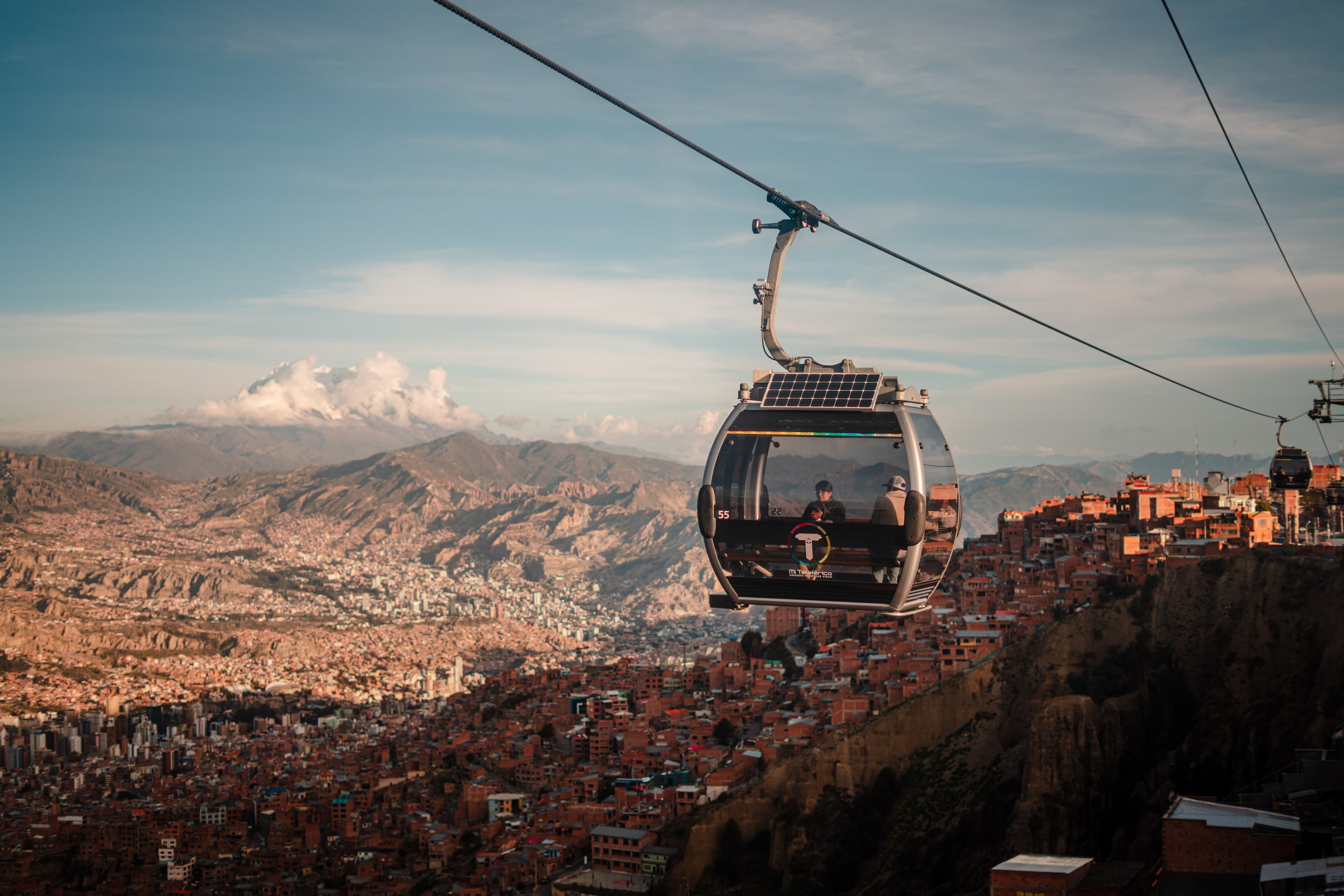
The Mi Teleférico network is a verified transport attraction. Line-specific times and step-free transfers were not confirmed. A ride is an easy way to see the city from above after the race, but it is not a pre-start shuttle.
After the Race
The marathon is on a Sunday in the March rainy season, and the first free days are best spent low and slow: the Valle de la Luna is next to the finish, the old centre needs a car for the hills, and the lake and the salt flat are longer journeys at similar altitude. Check current road and flight services, because protests and roadblocks have disrupted travel in recent months.
A morning among the eroded clay formations a day or two after the race, with a driver and short walks. March ground is wet, so wear shoes with grip.
Keep your room, rest for a day, then visit the Calle Jaén museums and Plaza Murillo with a car for the hills.
Two nights on the lake after the race, with level walks at the water's edge and a day for the island.
A longer extension for those with time, which needs altitude planning and a flexible plan in the March rainy season.